
Thousands of satellites, airplanes, helicopters, and drones collect images of our planet every day, but to determine which is best, you have to consider what you’re doing with that image, and which capabilities are most important.

Most recent videos
 2:49
2:49Maxar for Energy
From mapping to monitoring, Maxar helps energy companies stay ahead of risk and optimize operations with advanced geospatial data and insights.
 0:53
0:53Maxar's WorldView Legion Launch 2
The next two WorldView Legion satellites joining our industry-leading Maxar constellation will be our first in mid-inclination orbit, and we’re excited to soon have 30 cm-class imaging capabilities at
 1:29
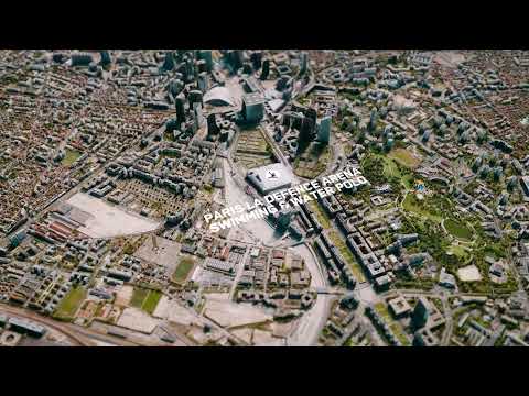
1:29#TiltTheMap: Paris, France 2024
Maxar’s #TiltTheMap series visits Paris, France, for the biggest competition of the year. Explore a digital twin of the “City of Love” in full 3D where more than ten thousand athletes will participate
 1:03
1:03Maxar's WorldView Legion Launch 1
Maxar’s successful history in space technology has guided the creation of our next-generation satellites. From defense and intelligence to living maps for navigation, WorldView Legion satellite imager
 2:13
2:13Maxar ClimateDesk: Global Climate Data and Analytics Platform
ClimateDesk, a climate intelligence and analytics platform, transforms climate risk into business opportunities. Learn more about ClimateDesk: https://www.maxar.com/products/climatedesk
 1:05
1:05Experience the Digital Twin of Earth Built to Connect XR with the Real World
Maxar is unifying physical and virtual worlds by providing the trusted geospatial foundation to ground simulations in reality and bring innovation to life. Whether you are powering your augmented real
 1:30
1:30#TiltTheMap: Las Vegas, Nevada
Maxar’s #TiltTheMap series explores Las Vegas, Nevada. Take a stroll down the strip and explore how the highest quality 3D geodata enables 3D maps for autonomous navigation, 5G network planning, and d
 1:51
1:51As the metaverse becomes a reality, it fulfills the promise of enriching our lives and fostering human connections around the world. Maxar is building Earth’s digital twin as a foundation to power the
 1:32
1:32Maxar Analysis-Ready Data Overview
Skip straight to analysis with Maxar’s Analysis-Ready Data (ARD). ARD is pre-processed time-series stacks of imagery that are aligned and produced at a set standard for change detection, mapping and m
 1:06
1:06Maxar for Defense
From broad-area surveillance to precise object detection, defense and intelligence organizations rely on Maxar’s rapid operational GEOINT to maintain a technological edge and achieve decision superior
 9:11
9:11The Strength of Maxar’s Combined Offerings for National Security Missions
Carrie Drake, Director of Government Marketing at Maxar, shares how the strength of Maxar’s combined offerings can help the United States defense and intelligence communities reach their modernization
 1:23
1:23Foundation Product Family
Only Maxar provides the trusted geospatial foundation needed for any mission, at any scale, whether you need an imagery layer for mapping, analysis-ready data for identifying change or 3D data for mis
 9:44
9:44The Strength of Maxar’s Combined Offerings for National Security Missions
Carrie Drake, Director of Government Marketing at Maxar, shares how the strength of Maxar’s combined offerings can help the United States defense and intelligence communities reach their modernization
 1:37
1:37Maxar Analysis-Ready Data (ARD) Overview
Skip straight to analysis with Maxar’s Analysis-Ready Data (ARD). ARD is pre-processed time-series stacks of imagery that are aligned and produced at a set standard for change detection, mapping and m
 2:02
2:02From Sensor to Decision
From the board room to the battlefield, from the command center to the climate research lab, decision-makers seek near real-time information about Earth at scale. From sensor to decision, Maxar produc
 32:52
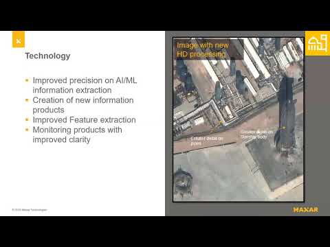
32:52I Can't Believe It's Not Aerial: Innovations in Satellite Imagery
Advances in Earth Observation satellites and image processing technology have expanded the utility of satellite imagery, making it a viable solution for many planning and mapping needs that were once
 2:12
2:12In a 30 cm resolution image, you could determine if vehicles are pickup trucks, sedans, or convertibles, as well as their direction of travel.
 2:13
2:13We are talking about Positional Accuracy! It's about how close a pixel is in relation to it true, know position on Earth.
