#TiltTheMap: Ethiopia
Maxar's #TiltTheMap series explores Ethiopia. Behind the dots on a map is the real world. 3D models provide decision-makers and journalists with context they need for hard-to-reach locations.

Maxar's #TiltTheMap series explores Ethiopia. Behind the dots on a map is the real world. 3D models provide decision-makers and journalists with context they need for hard-to-reach locations.
 0:32
0:32We've constructed 100 million square kilometers of unique global 3D terrain data coverage. This milestone represents 95% of the highest-interest parts of the world captured with meter-level precisio
 4:33
4:33How do drones navigate without GPS or extra hardware? Raptor, a suite of vision-based software products that use Maxar’s unique global 3D data, delivers a breakthrough terrain-based positioning syst
 1:22
1:22Maxar's Precision3D provides a digital twin of Earth for outdoor mapping applications.
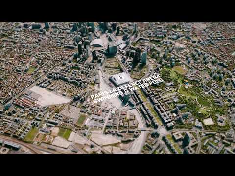 1:29
1:29Maxar’s #TiltTheMap series visits Paris, France, for the biggest competition of the year. Explore a digital twin of the “City of Love” in full 3D where more than ten thousand athletes will participate
 1:05
1:05Maxar is unifying physical and virtual worlds by providing the trusted geospatial foundation to ground simulations in reality and bring innovation to life. Whether you are powering your augmented real
 0:59
0:59To accelerate the creation of augmented reality (AR)/virtual reality (VR) experiences, it needs to be easier to enable more location-based precision in AR applications and to develop VR experiences th
 1:41
1:41Maxar’s #TiltTheMap series visits Barcelona, Spain for Mobile World Congress, the largest and most influential event for the connectivity ecosystem. Explore the digital twin of this vibrant city in fu
 0:45
0:45Maxar’s #TiltTheMap series partners with Blackshark to explore New Orleans, Louisiana, U.S. Fueled by Maxar’s satellites, our high-resolution commercial imagery is processed with AI to create a digita
 1:35
1:35With Maxar’s Precision3D, new possibilities for planning, calibration and optimization emerge, bringing superior accuracy at a global scale to safe flight paths.
 1:24
1:24Maxar’s #TiltTheMap series explores New York City, U.S. From our highest quality commercial satellite imagery comes our 3D geodata, for accuracy, insight and exquisite detail.
 1:53
1:53With a continuous feed of the highest quality commercial satellite imagery and our patented 3D technology, only Maxar can build the Globe in 3D—the highest resolution, most accurate representation of
 1:36
1:36Maxar’s #TiltTheMap series explores Santiago, Chile. Our realistic, immersive 3D model—built from commercial satellite imagery—depicts one of the largest cities in the Americas: the financial and indu
 1:06
1:06Some situations require a complete picture, a view of the world the way it really is, in fully immersive 3D.
 4:23
4:23The Globe in 3D bridges the gap between geo-typical and geo-specific, bringing the training and operational missions together in a seamless environment.
 0:42
0:42With increased capacity and revisit, Maxar will be able to more quickly and accurately generate 3D.
 1:54
1:54P3DR is a software suite designed to automatically georegister imagery against the most accurate 3D foundation.
 2:45
2:45Telecommunications—from regions to urban cores, you need accurate geodata to improve current or plan for tomorrow’s networks.
 1:35
1:35Maxar brings this precision to military targeting and mission rehearsal with 3D satellite imagery.

